This section of the plug-in allows users to select a QGIS layer.
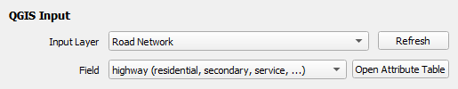
¶ Input Layer
The Input Layer dropdown contains a list of items reflecting the list of layers in the QGIS Layers panel. By default, the same layer will be selected as in the QGIS Layers panel.
A different layer can be selected at any time, although it is recommended to do it at the begining. Some settings will become available/unavailable depending on the GIS data type of the selected layer.
The Refresh button is available to refresh the list of items in the dropdown, should there be any updates to the list of layers in the QGIS Layers panel.
¶ Field
This parameter is only available when the selected Input Layer is a Vector GIS data.
The dropdown contains a list of items reflecting the fields of the selected vector layer. Each item displays the field name accompanied with a preview of at most 3 of its attributes.
The Open Attribute Table button is available to view the full list of fields associated with the selected shapefile and the accompanying attributes for each field.